Alaska Magazine is a very popular monthly periodical. One nice feature is tucked away on the inside back page of each edition. It’s a photograph of some location in Alaska with the challenge for readers to guess where it was taken. The answer is revealed in the next edition.
Recently, Cordovan Ron Goodrich, who most of you know as your tax guru, posted on Facebook a fascinating series of photos taken by his mother Pat Goodrich. The photos were of outstanding quality and show glimpses of Cordova and the area several decades ago.
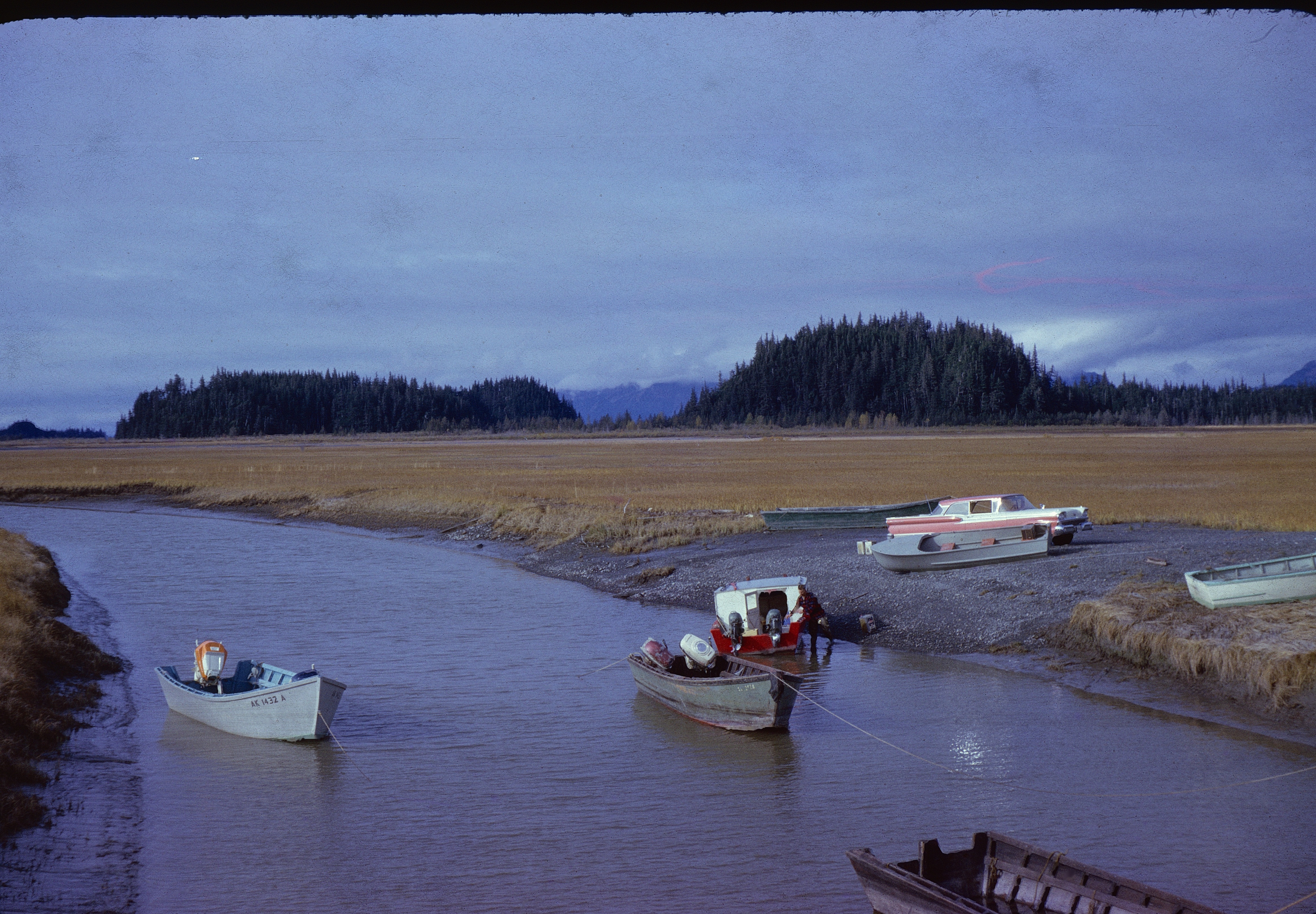
One photo shows several boats anchored in a slough, with a flashy red and white 1959 Ford sedan in the background. Several boats, including four work skiffs, a cabin skiff, and two small run-a-bouts, are also visible. Closer scrutiny reveals a man loading fuel in rectangular metal five-gallon Blazo fuel cans into the cabin skiff.
One of the work skiffs is high and dry, as are the run-a-bouts. The other skiffs are afloat with anchors lines out and bow lines extending out of the edge of the photo.
The questions are “Where was the photo taken?” and “What are those boats doing there?” Well, the background gives a clue. The forested knob to the right looks familiar, and in fact is the location of today’s popular Haystack Trail.
What is confusing is the surrounding plains of yellow grass and a complete lack of brush or trees. Also, where the heck do those bow lines off the skiffs go? And how did the boats that are high and dry get there?

Well, if you happened to be around prior to 1964 earthquake you would recognize this as the original boat ramp to access Alaganik Slough. The boats that are high and dry were simply left there to launch on the next high tide.
This landing was located about a mile beyond the Haystack Trail turnout, and this unusual fleet of boats was used to access duck cabins throughout the Delta.
The boat bow lines were tied to the guard rails of a wooden bridge crossing the slough, and stern anchors sometimes kept the bigger skiffs in the slough. High tides came up to and over the tops of the slough banks, preventing the growth of willow, alder and cotton wood, plus eventually spruce and hemlock.
Today at Mile 19, all that remains is a big culvert that replaced the wooden bridge, plus a deep hole. The slough is now nothing but a shallow gutter blocked by beaver dams and surrounded by tall trees and brush.
This landing was used to access Alaganik Slough until the ‘64 earthquake uplift of 9 feet left this location high and dry. To their credit, the U.S. Forest Service immediately addressed the problem and within two years the present Alaganik road and boat landing was completed.
Since then, it has undergone several improvements, including a popular picnicking area and elevated viewing platform.
The days of traveling the Delta’s sloughs with prop driven skiffs were soon over. Today river boats powered by outboard jets or airboats are the common answer to the shallow sloughs of the Delta.
Incidentally, the light blue skiff in the photo belonged to Cordova banker Dick Borer and was powered by a then-unthinkable 50 horsepower outboard.
The grey-hued work skiff in with two outboards near the red and white cabin skiff was ours. Dad installed Styrofoam flotation under the floorboards, so the boat was self-bailing when left there during the week. I spent many an adventure standing between the pair of 18 horse outboards steering to our duck cabin down at Pete Dahl Slough.
Each fall when we closed up the duck cabin we ran the boat all the way to Whitshed and then to town.